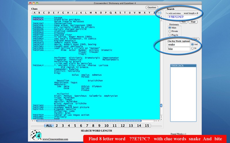
Gazetteer
Advertisement

GeoDataSource World Cities Database (Gold Edition) v.April.2013
GeoDataSource Cities Database Gold Edition contains city names, feature type classifications, country names in FIPS and ISO, regions, sub-regions, state, county, longitude and latitude in degree and decimal, UTM coordinate grid and JOG reference.
Advertisement

GeoDataSource World Cities Database (Premium Edition) v.April.2013
GeoDataSource Cities Database Premium Edition contains city names in original language and English, feature type classifications, country names in FIPS and ISO, regions and sub-regions, state and county. Database available in text format.

GeoDataSource World Cities Database (Free Edition) v.April.2013
GeoDataSource Free Cities Edition provides geographical database of world features, cities with place names and region names.
Korti v.2 8
Korti is a Google Earth plugin which allows you to see the unique 3D satellite map of Korti within your Google Earth application. Korti provides you a detailed satellite imagery and geographic information about this geographic place.
TrackLogs Digital Mapping v.3.15.1
TrackLogs Digital Mapping include genuine Ordnance Survey digital data and are visually identical to the paper Explorer and Landranger maps. The maps show footpaths, bridleways and contours, just like the paper ones.
Roadnav v.0.19
Roadnav is an open source street navigation solution capable of running on a variety of operating systems. It can obtain your position from a GPS unit, plot a map of your area, and provide directions to locations in the USA.
Petacon v.1.0
Get a full 3D satellite map view of El Petacon on your PC. If you have already installed Google Earth, you will be able to view the El Petacón 3D map.
Nanako v.1 1
Nanako is a useful tool for Google Earth 3D map which allows you to view the exciting places of Nanako. If you have installed on your PC Google Earth tool, you can view the 3D map of Nanako places.
Veruela v.2 1
Veruela is a Google Earth utility which provides you images from Veruela geographical area.
GeoDataSource World Land Features Database (Basic March v.2007
GeoDataSource Land Features Database Basic Edition contains land feature names in original language and English, feature type classifications, country names in FIPS and ISO, regions and sub-regions.
GeoDataSource World Water Features Database (Premi February v.2
GeoDataSource Water Features Database Premium Edition contains water feature names in original language and English, feature type classifications, country names in FIPS and ISO, regions and sub-regions.